Munich (district)
| Munich | |
|---|---|
| — District — | |
 |
|
| Country | |
| State | Bavaria |
| Adm. region | Oberbayern |
| Capital | Munich |
| Area | |
| - Total | 667.27 km2 (257.6 sq mi) |
| Population (31 December 2009)[1] | |
| - Total | 319,573 |
| - Density | 478.9/km2 (1,240.4/sq mi) |
| Time zone | CET (UTC+1) |
| - Summer (DST) | CEST (UTC+2) |
| Vehicle registration | M (followed by one letter) |
| Website | http://www.landkreis-muenchen.de |
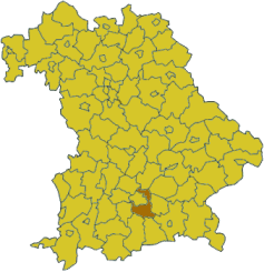
Munich (German: Landkreis München) is a district in Bavaria, Germany. It borders (from the north and clockwise) the districts of Dachau, Freising, Erding, Ebersberg, Rosenheim, Miesbach, Bad Tölz-Wolfratshausen, Starnberg, Fürstenfeldbruck, and surrounds district-free city Munich itself, which is the district seat.
Contents |
History
The history of the region is connected to the city of Munich.
The district was established in 1852 and underwent several changes due to the ongoing incorporation of municipalities into the city of Munich. In 1972 the constant shrinking of the district was compensated by adding nine municipalities from the former district of Wolfratshausen.
Geography
The district is located in the east and the south of the city Munich, mostly covering the moraine plain around Munich. In the south of the district the foothills of the Alps start, which also contain the highest elevation of the district, two hills 703 m above sea level in the municipality Schäftlarn. The lowest elevation with 471 m is near Unterschleißheim in the north of the district. The main river is the Isar, which also flows through the city of Munich.
Coat of arms
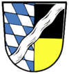 |
The left half of the coat of arms show the Bavarian blue-and-white lozenge symbols. The black and gold (mostly simplified to yellow) colors in the right half are the colors of the city Munich. On top is a wavy line, which symbolizes the river Isar. |
District Mayors
| District Mayors | Party | Term in office | ||
|---|---|---|---|---|
| Georg Ignaz Kuttner | 1839–1844 Landrichter (District Justice) |
|||
| Michael Eder | 1845–1853 Landrichter (District Justice) |
|||
| Karl Aug. Mechel | 1854–1862 Landrichter (District Justice) |
|||
| Georg von Grundner | 1863–1870 Bezirksoberamtmann (District Official-in-Chief) |
|||
| Josef Hermann | 1871–1874 Bezirksamtmann (District Official-in-Chief) |
|||
| Rudolf von Roman | 1875–1879 Bezirksoberamtmann (District Official-in-Chief) |
|||
| Bernhard Voglerr | 1880–1886 Bezirksoberamtmann (District Official-in-Chief) |
|||
| Emil Pündtner | 1887–1896 Bezirksoberamtmann (District Official-in-Chief) |
|||
| Emil Geis | 1896–1904 Bezirksoberamtmann (District Official-in-Chief) |
|||
| Siegmund von Schacky | 1905–1913 Bezirksoberamtmann (District Official-in-Chief) |
|||
| Franz Heinz | 1913–1927 Bezirksoberamtmann (District Official-in-Chief) |
|||
| W. Freiherr von Stengel | 1927–1931 Bezirksoberamtmann (District Official-in-Chief) |
|||
| Max Mayer | 1932–1938 Bezirksoberamtmann (District Official-in-Chief) |
|||
| Emil Schick | 1938–1943 Landrat (District Mayor) |
|||
| Georg Schmid | 1943–1945 Landrat (District Mayor) |
|||
| Hans Staub | 1945–1947 Landrat (District Mayor) |
|||
| Karl Balling | 1947 Landrat (District Mayor) |
|||
| Rudolf Gunst | 1947–1948 Landrat (District Mayor) |
|||
| Peter Hecker | CSU | 1 June 1948 – 30 April 1970 Landrat (District Mayor) |
||
| Joachim Gillessen | CSU | 1 May 1970 – 30 April 1996 Landrat (District Mayor) |
||
 |
Heiner Janik | CSU | 1 May 1996 – 30 April 2008 Landrat (District Mayor) |
|
| Johanna Rumschöttel | SPD | since 1 May 2008 Landrätin (District Mayor) |
||
Towns and municipalities
| Towns | Municipalities | |
|---|---|---|
|
|
|
Government
The district ist administered by the Landratsamt München and politically lead by the Kreistag.
External links
- Official website (German)
|
||||||||
Cite error: <ref> tags exist, but no <references/> tag was found